Showing posts with label Morro Rock. Show all posts

Wednesday, June 19, 2019

Lost in the Elfin Forest in Los Osos in June

How Not to Get Lost in the Elfin Forest


Part of the Elfin Forest Boardwalk with Black Sage in the Foreground, © B. Radisavljevic

A boardwalk loop is the only trail through the Elfin Forest. Once on the boardwalk, it's hard to get lost in the Elfin Forest. There are signs to lead you to every boardwalk destination. You can find the signs and maps to borrow at each entrance. More signs all along the boardwalk explain what you are seeing. Notice the map of the layout on the photo below. It marks all the entrances. On our first visit we entered on 16th Street, a fact I couldn't remember on this visit. Rather I had noted that a boardwalk trail led to the main boardwalk. So I assumed all the entrances were like this. You can read about that first visit in January 2014, here.
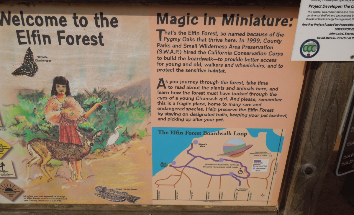
Visitor Information Sign. Notice the Map on the Lower Right of the Layout of Trails, © B. Radisavljevic
Look carefully at the map above. Each entrance is located at the end of a residential street. There are some designated handicapped parking spaces at the end of 16th Street and the boardwalk from the parking area to the main boardwalk makes the forest wheelchair accessible at this  entrance. The many benches along the boardwalk offer those who can't walk long distances a place to rest frequently. Because we parked on 16th Street on our first visit we didn't realize that all the other paths leading to the main boardwalk were sand paths. Some, like this one, below, required a step up with no rail to grab.

White Yarrow Hangs Over Root "Step" on Sand Path Leading to Main Boardwalk
Roots in path could trip people who don't see them in time. © B. Radisavljevic

It's Easier to Get Lost On the Way Back to Your Car

We had forgotten which entrance was handicapped accessible on this second visit since we hadn't been here in over five years. I had planned to go directly to Siena's View that overlooks Morro Bay, so I chose the 12th Street entrance. Santa Ysabela, a main street, leads to all the entrances of the Elfin Forest. There are entrances from 17th, 16th, 15th, 14th, 13th, 12th, and 11th Streets. 

We arrived at the forest at around 5:00 on a Monday evening in June. I quickly discovered that there was no place to park close to the 12th Street entrance. It was trash day, so all the street parking spaces were cut short by the trash containers. I had to back up until I could get to a driveway to turn around in. 

Luckily traffic on Santa Ysabela wasn't too bad so I was able to go back to 14th Street without too much trouble. I did find a place to park there. The friendly person who lived in the house we parked in front of told us when we wanted to find our way back to just look for the telephone pole. He said it was the only one in the Elfin Forest. This is what that entrance looks like. I wish I had taken the picture when I entered instead of when I got back. 


On this visit my husband was suffering from a sore knee and when I saw that the entrance only had a sand trail leading to the boardwalk, I knew my husband would never make it. But the view from the car was good, the weather was cool, and Hubby opted to stay in the car with the windows open and just observe while I went onto the trail to take pictures. It turns out he saw more wildlife from the car than I saw on the trail. I only saw one cottontail. He saw several. I saw birds, a coyote, and several lizards like the one below. E

Lizard on Boardwalk, Elfin Forest, Los Osos, June, 2019, © B. Radisavljevic

I didn't dare get close enough to get a better photo without the shadow since the lizard was pretty fast. I was sure it would disappear if I got closer so I did the best I could with my zoom. The flower hanging into the boardwalk is one of the many black sage plants that seemed to be everywhere and buzzing with bumblebees. 

The Flowers


The main reason we had made this visit was so that I could photograph some of the flowers in June. Very little was blooming on our January visit. I wouldn't exactly call it a garden on this visit, but at least there was more color. I was especially looking for this sticky monkey flower, and I wasn't disappointed. 

Sticky Monkey Flower in Elfin Forest, June 2019, © B. Radisavljevic
As I showed you above, the white yarrow was also blooming, and there was black sage almost everywhere you looked. I was able to photograph the sage, but the bumblebees foraging were too quick to capture with my camera. I was hoping they wouldn't invade my space on the boardwalk. They were very loud, but I guess they were contented. 

Black Sage in the Elfin Forest in June, © B. Radisavljevic

I took close to 200 photos, but the rest I'm saving for another blog. In this post I want to help you avoid what happened to me on the way back to the car. 

How I Got Lost


By the time I had walked for about an hour, I knew I should get back to the car in case my husband was getting tired of sitting there. I should have known better. When I finally did get back, he wasn't even there. 

But getting back wasn't as easy as I expected. It's true there was only one telephone poll within the Elfin Forest, but there were many just outside of it close to the other streets. I had forgotten which street we were parked on. Had I remembered, getting back would have been much easier. The boardwalk marked most, but not all exits with signs like the one below. You can't read it, but it says that trail leads to exits on 11th, 12, and 13th Streets. 


Since I seemed to remember parking on 13th Street, I took this exit. The car was not on the exit where I wound up. What looked like a continuation of the trail at the end was really someone's driveway. 

I called my husband to see how he was doing and he was fine. I told him I was lost and asked him about the colors of the houses around him. I could see the end houses for almost all the streets from where I stood, but not any poles I was sure were in the forest. All the telephone poles I saw appeared to be in the forest until I got closer to them. I told Hubby I'd be back to the car as soon as I could find my way back. 

After talking to a few people I met along the boardwalk, I finally took their advice and tried the 14th Street exit, which was clearly marked with a sign. It did lead me back to the car -- but the car was empty. I called my husband again, and he told me he was using a bathroom. Of course I knew there were no public bathrooms in the area so I was confused until I saw him walking toward me from a driveway. He'd gotten into a conversation with the neighbor who had told me to look for the pole. I also learned the man had gone looking for me. His wife called to tell him I had returned. She also invited me to use her bathroom, for which I was grateful. 

How I Could Have Avoided Getting Lost


As soon as I got to the boardwalk, I should have turned and used my phone to take a photo of the entrance to the path I'd used the way it would look to get back on it . Or I could have made a note of the street name where I had parked the car. Had I done that I would have been able to find my way back from a sign by the trail entrance or by the photo of how the entrance to the way back looks. I also could have noted the colors of the houses on the street closest to the trail access or taken photos of them. Knowing the name of the street would have been the most useful, since then when I asked the way back people would have known how to direct me. 

Hindsight is great. I share this with you in case you are as impulsive as I am. If you do what I didn't, you probably will have no trouble getting back to your car after a walk in the Elfin Forest.

In spite of getting lost, I still enjoyed the walk and wish I'd stayed longer. "All's well that ends well," as the Bard said. By the time I found my way back, the sun had begun to hide in the clouds over Morro Bay. 

Looking Toward Morro Bay from the Elfin Forest Boardwalk, © B. Radisavljevic
   

Monday, April 18, 2016

Ocean Photos from the California Central Coast

Ocean Photos from the California Central Coast
Coast from Leffingwell Landing, Cambria,
 © B. Radisavljevic


One can approach the ocean from Paso Robles in many ways. Probably the closest beaches to Paso Robles are Cambria, San Simeon State Beach, and Cayucos. Continue south on Highway 1 or take 101 to Highway 41 to reach Morro Bay. Just a bit farther south and you will be at Avila Beach and Pismo Beach. Each beach and coastal city has its own unique character, and most locals have a preferred beach where they like to access the ocean. My personal favorite is Moonstone Beach, and next would be Avila Beach. The photo essays I just linked to will show you an extensive look at each beach in photos and videos as I experienced them. I will introduce some different and more recent photos here. I'm glad the ocean is only a short distance from Paso Robles, and I can get to any of my favorite beaches quickly. 

One of my favorite places to access the ocean in Cambria is Leffingwell Landing. Below are some of the reasons why.

Leffingwell Landing is one place where I can go with Hubby, who has difficulty walking very far, where he can sit and watch the ocean while I walk the boardwalk and we are both happy.  There are also restrooms easily accessible. I think the sun is in his eyes in this photo.

Ocean Photos from the California Central Coast
Hubby Watching Ocean from Leffingwell Landing, Cambria, © B. Radisavljevic

Leffingwell Landing is a place where children can be active while getting their own personal taste of nature. I remember how my own children loved to climb on the rocks when we went to a beach that had them. They would  have loved the Cambria coastline.

Ocean Photos from the California Central Coast
Children Climbing Rocks at Leffingwell Landing, Cambria, © B. Radisavljevic

Here's one more  shot of the ocean from Cambria before we move on. I love the way the sun reflects on the ocean.

Ocean Photos from the California Central Coast
Sun Reflecting on Ocean at Leffingwell Landing, Cambria, © B. Radisavljevic


Before we leave the North Coast, here's one shot taken at San Simeon State Beach.

Ocean Photos from the California Central Coast
Cove at San Simeon State Beach, © B. Radisavljevic


If you watch my video, you can  hear the ocean at San Simeon, as well as see it.


Now we will move south to Cayucos. When I think of Cayucos I think of not only the ocean and the beach, but also the seaweed and the patterns formed by the waves on the sand.

Ocean Photos from the California Central Coast
Wave-formed Patterns on the Sand at Cayucos, © B. Radisavljevic


Ocean Photos from the California Central Coast
Shadow of Pier on Kelp in Water Beside Cayucos Pier, © B. Radisavljevic

We can't leave Cayucos without a shot of a sea gull, since the gulls own the place.

Ocean Photos from the California Central Coast
Gull on Shore at Cayucos Beach, © B. Radisavljevic
Time to move south to Morro Bay now.  Morro Bay's most famous landmarks are its smokestacks and Morro Rock. Since I'm focused on the ocean, I'll show you the rock. Since Morro Bay is a fishing village, it is usually surrounded by boats.

Ocean Photos from the California Central Coast
Morro Rock and Fishing Boats, © B. Radisavljevic
The gulls own Morro Bay as they do every other Central Coast beach or pier I've been to. This one just  took off from the pier.

Ocean Photos from the California Central Coast
Morro Bay Sea Gull in Flight, © B. Radisavljevic
It's time to move on to Avila Beach, which actually is two beaches. There's the one near town with a more typical sandy beach, and there is also Port San Luis. These photos were taken at Port San Luis because there is more wildlife to look at. Below is a gull on the rocks deciding whether to go fishing.

Ocean Photos from the California Central Coast
Port San Luis in Avila Beach Sea Gull on Rock, © B. Radisavljevic


Below are more sights and sounds from Avila Beach, Port San Luis.

As usual, the sea gulls have staked their claim on the Harford Pier.

Ocean Photos from the California Central Coast
Port San Luis,  Avila Beach Sea Gulls on Pier, © B. Radisavljevic

Our last stop will be Pismo Beach. It's a popular beach with people and seagulls. Don't leave your picnic food unattended. It will soon be surrounded. This is what happened to one ice chest left by itself on the beach. It's like an airport restaurant for seagulls.


Here's a glimpse of people enjoying Pismo Beach near the pier.

Ocean Photos from the California Central Coast
People Enjoying Pismo Beach Near Pier, © B. Radisavljevic

Below is the view many people visualize when they think of Pismo Beach.

Ocean Photos from the California Central Coast
 Pismo Beach, California, © B. Radisavljevic
Here are some of my more popular Zazzle products made from photos taken at Pismo Beach, in case you missed picking up a souvenir last time you were there.


If you enjoyed this post, please share it. The sharing buttons are just above the comment box at the end of this post. The photo below is especially designed for pinning.

Thursday, January 7, 2016

Photos of San Luis Obispo County Old Rocks to Celebrate Old Rock Day

Photos of  San Luis Obispo County Old Rocks to Celebrate Old Rock Day
Fisherman Near Morro Rock, ©B. Radisavljevic

Morro Rock


Someone somewhere decreed that January 7 is National Old Rock Day. San Luis Obispo County has plenty of large rocks and boulders, but they don't come labeled with their ages. A rock has to be pretty well known for someone to have researched its age. Franciscan missionary Juan Crespo , who was with the Portola Expedition in 1769 made note of the rock in his diary. (Wikipedia) The same source says the Chumash and Salian native nations considered Morro Rock to be a sacred site, and they may have been there before the birth of Christ. I think I can say with some assurance that Morro Rock qualifies as an old rock for Old Rock Day.

Prominent Rocks in Pismo Beach


Photos of  San Luis Obispo County Old Rocks to Celebrate Old Rock Day
Huge Rock on Highway 101 in Pismo Beach, © B. Radisavljevic
Morro Bay does not have a monopoly on large rocks and boulders. Pismo Beach and other coastal cities have their share as well. Here are some of the photos I have taken of prominent rocks in Pismo Beach. This one can be seen by anyone driving through Pismo Beach on Highway 101. I took this photo in front of what was then the Marie Callender's in Pismo Beach. It has since closed. The rock remains between the north and southbound lanes of the freeway.

Photos of  San Luis Obispo County Old Rocks to Celebrate Old Rock Day
Great Rock on Pismo Beach, © B. Radisavljevic

To see the other Pismo Beach rocks I photographed you need to be right on the beach. I have isolated this one from its background, which you will see below. It is easily accessible to people enjoying the beach.

The entire photo this was cut from is below. The coastal cliffs look just like bigger rocks that people have built on. I have no idea how old any of the Pismo rocks are, but I'm quite sure they would also be considered old rocks.


Photos of  San Luis Obispo County Old Rocks to Celebrate Old Rock Day
Enormous Rock on Beach in Pismo Beach, © B. Radisavljevic


Old Rocks in North County Wine Country


Photos of  San Luis Obispo County Old Rocks to Celebrate Old Rock Day
Rocks in My Herb Garden in Templeton, © B. Radisavljevic

Lest you think the South Coast of San Luis Obispo County has a monopoly on large old rocks and boulders, seeing the North County wineries would change your thinking. I'll begin at home in my unruly herb garden. It started around a rock -- that large rock between the upturned flower pot and the rosemary plant in the middle of the photo. 

You will notice there are many smaller rocks in front of it. These rocks are just a small part of the story. If you try to dig a hole over four inches deep almost anywhere on this property you will hit large pieces of shale. 


Most of the wineries near me in what is known as 46 West Wine Country have
also contended with this. There are simply too many rocks to haul away, so the wineries use them creatively to decorate and to use in fencing and signs. Here are some examples. 


Old Rocks on the Eagle Castle / Tooth and Nail Grounds 


Photos of  San Luis Obispo County Old Rocks to Celebrate Old Rock Day
Boulders  at Tooth and Nail Winery, © B. Radisavljevic


We will start with the grounds of what used to be Eagle Castle and is now Tooth and Nail Winery. I took these photos during the Eagle Castle era, but the rocks have remained. One look will tell you why they might not have wanted to move them. They now serve a decorative function. 

Photos of Old San Luis Obispo County Rocks to Celebrate Old Rock Day
Boulders on Grounds at Tooth and Nail Winery, © B. Radisavljevic

This photo shows a couple of these rocks closer up. As you can see, they are enormous and firmly planted. Hauling them away would be no small feat. If you drive west on Highway 46 and visit the wineries, you will find large rocks like this somewhere on the grounds of most of them.


Rocks at Rotta Winery


Photos of  San Luis Obispo County Old Rocks to Celebrate Old Rock Day
Rock Pile at Rotta Winery, © B. Radisavljevic
Moving west we next reach Rotta Winery, which is on Winery Road, just south of 46 West off Vineyard Drive. Rotta, is one of the oldest wineries in the county. There have been vineyards there since 1856. This is a dry-farmed vineyard. They probably had to drag those rocks out of the ground to plant it.


Photos of  San Luis Obispo County Old Rocks to Celebrate Old Rock Day
Stored Rock at Rotta Winery, © B. Radisavljevic
Rotta has used the rocks on its property in fencing, for decorating, and probably for uses I don't know about. I do know that it's hard to be at Rotta for very long without seeing some huge rocks. I assume they are also old rocks.  I took these photos at the end of March, 2014. I'm not sure what these rocks had been or were about to be used for.  They haven't been here by the old winery every time I've visited. This historic building was destroyed by the earthquake of 2003.  It is part of a historical exhibit now.


Photos of Old San Luis Obispo County Rocks to Celebrate Old Rock Day
Boulders at Rotta Winery, © B. Radisavljevic


This row of giant rocks in the photo above decorates the entrance to the Rotta tasting room. I can just imagine how much fun it was to get these out of the ground. 

Old Rocks at Shale Oak Winery


Photos of  San Luis Obispo County Old Rocks to Celebrate Old Rock Day
Rocks Stairs at Shale Oak Winery, © B. Radisavljevic

Shale Oak Winery is a bit North of Rotta as the crow flies. It's on Oakdale Road which runs north off Highway 46 West before you get to Vineyard Drive. It appears they had also a lot of large rocks to deal with. They painted their logo and placed their sign on a boulder. Some of the rocks mark the boundary of their road and parking lot. It appears they also built these stairs up the hill with their rocks. That's the most unique use I saw, so I'm only showing you this photo.


Old Rock at Jack Creek Farm


Photos of  San Luis Obispo County Old Rocks to Celebrate Old Rock Day
Toddler Climbing Boulder at Jack Creek Farm, © B. Radisavljevic
Though not a winery, Jack Creek Farm, west of Vineyard Drive near Jack Creek Road, is still in wine country. It has its own large rock collection. You will see a rock  border between the parking lot and the buildings, and there are also plenty of substantial rocks scattered around the property. Most of them have decorative uses. This rock was near the edge of the parking lot beside a large pumpkin display. I couldn't resist taking this picture, which not only features this cute toddler, but also shows you how big the rock really is. That's part of a wine barrel on the right side.


This Ends My Mini-Tour of Old and Large Rocks 

San Luis Obispo County is so full of these rocks they are almost as common as the trees. Probably they are more common, since most of them are still buried out of sight. Some coastal rocks extend into the water. It would take a scientist to figure out just how old these rocks are, but some have been classified as Jurassic. Surely they are worthy of being celebrated on National Old Rock Day. 


The boulder above was photographed on a view point on Highway 46 West not far from Cambria. That location is not far from where a friend was hit by a boulder about this size during an earthquake on her own property. It broke her back, but she recovered and is lucky to still be alive. God is her rock. 


Related Posts Plugin for WordPress, Blogger...