Showing posts with label short hikes. Show all posts

Wednesday, June 19, 2019

Lost in the Elfin Forest in Los Osos in June

How Not to Get Lost in the Elfin Forest


Part of the Elfin Forest Boardwalk with Black Sage in the Foreground, © B. Radisavljevic

A boardwalk loop is the only trail through the Elfin Forest. Once on the boardwalk, it's hard to get lost in the Elfin Forest. There are signs to lead you to every boardwalk destination. You can find the signs and maps to borrow at each entrance. More signs all along the boardwalk explain what you are seeing. Notice the map of the layout on the photo below. It marks all the entrances. On our first visit we entered on 16th Street, a fact I couldn't remember on this visit. Rather I had noted that a boardwalk trail led to the main boardwalk. So I assumed all the entrances were like this. You can read about that first visit in January 2014, here.
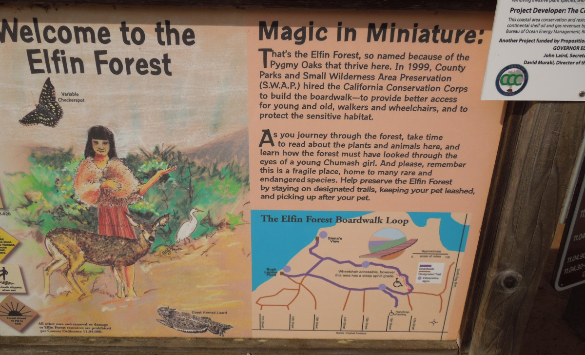
Visitor Information Sign. Notice the Map on the Lower Right of the Layout of Trails, © B. Radisavljevic
Look carefully at the map above. Each entrance is located at the end of a residential street. There are some designated handicapped parking spaces at the end of 16th Street and the boardwalk from the parking area to the main boardwalk makes the forest wheelchair accessible at this  entrance. The many benches along the boardwalk offer those who can't walk long distances a place to rest frequently. Because we parked on 16th Street on our first visit we didn't realize that all the other paths leading to the main boardwalk were sand paths. Some, like this one, below, required a step up with no rail to grab.

White Yarrow Hangs Over Root "Step" on Sand Path Leading to Main Boardwalk
Roots in path could trip people who don't see them in time. © B. Radisavljevic

It's Easier to Get Lost On the Way Back to Your Car

We had forgotten which entrance was handicapped accessible on this second visit since we hadn't been here in over five years. I had planned to go directly to Siena's View that overlooks Morro Bay, so I chose the 12th Street entrance. Santa Ysabela, a main street, leads to all the entrances of the Elfin Forest. There are entrances from 17th, 16th, 15th, 14th, 13th, 12th, and 11th Streets. 

We arrived at the forest at around 5:00 on a Monday evening in June. I quickly discovered that there was no place to park close to the 12th Street entrance. It was trash day, so all the street parking spaces were cut short by the trash containers. I had to back up until I could get to a driveway to turn around in. 

Luckily traffic on Santa Ysabela wasn't too bad so I was able to go back to 14th Street without too much trouble. I did find a place to park there. The friendly person who lived in the house we parked in front of told us when we wanted to find our way back to just look for the telephone pole. He said it was the only one in the Elfin Forest. This is what that entrance looks like. I wish I had taken the picture when I entered instead of when I got back. 


On this visit my husband was suffering from a sore knee and when I saw that the entrance only had a sand trail leading to the boardwalk, I knew my husband would never make it. But the view from the car was good, the weather was cool, and Hubby opted to stay in the car with the windows open and just observe while I went onto the trail to take pictures. It turns out he saw more wildlife from the car than I saw on the trail. I only saw one cottontail. He saw several. I saw birds, a coyote, and several lizards like the one below. E

Lizard on Boardwalk, Elfin Forest, Los Osos, June, 2019, © B. Radisavljevic

I didn't dare get close enough to get a better photo without the shadow since the lizard was pretty fast. I was sure it would disappear if I got closer so I did the best I could with my zoom. The flower hanging into the boardwalk is one of the many black sage plants that seemed to be everywhere and buzzing with bumblebees. 

The Flowers


The main reason we had made this visit was so that I could photograph some of the flowers in June. Very little was blooming on our January visit. I wouldn't exactly call it a garden on this visit, but at least there was more color. I was especially looking for this sticky monkey flower, and I wasn't disappointed. 

Sticky Monkey Flower in Elfin Forest, June 2019, © B. Radisavljevic
As I showed you above, the white yarrow was also blooming, and there was black sage almost everywhere you looked. I was able to photograph the sage, but the bumblebees foraging were too quick to capture with my camera. I was hoping they wouldn't invade my space on the boardwalk. They were very loud, but I guess they were contented. 

Black Sage in the Elfin Forest in June, © B. Radisavljevic

I took close to 200 photos, but the rest I'm saving for another blog. In this post I want to help you avoid what happened to me on the way back to the car. 

How I Got Lost


By the time I had walked for about an hour, I knew I should get back to the car in case my husband was getting tired of sitting there. I should have known better. When I finally did get back, he wasn't even there. 

But getting back wasn't as easy as I expected. It's true there was only one telephone poll within the Elfin Forest, but there were many just outside of it close to the other streets. I had forgotten which street we were parked on. Had I remembered, getting back would have been much easier. The boardwalk marked most, but not all exits with signs like the one below. You can't read it, but it says that trail leads to exits on 11th, 12, and 13th Streets. 


Since I seemed to remember parking on 13th Street, I took this exit. The car was not on the exit where I wound up. What looked like a continuation of the trail at the end was really someone's driveway. 

I called my husband to see how he was doing and he was fine. I told him I was lost and asked him about the colors of the houses around him. I could see the end houses for almost all the streets from where I stood, but not any poles I was sure were in the forest. All the telephone poles I saw appeared to be in the forest until I got closer to them. I told Hubby I'd be back to the car as soon as I could find my way back. 

After talking to a few people I met along the boardwalk, I finally took their advice and tried the 14th Street exit, which was clearly marked with a sign. It did lead me back to the car -- but the car was empty. I called my husband again, and he told me he was using a bathroom. Of course I knew there were no public bathrooms in the area so I was confused until I saw him walking toward me from a driveway. He'd gotten into a conversation with the neighbor who had told me to look for the pole. I also learned the man had gone looking for me. His wife called to tell him I had returned. She also invited me to use her bathroom, for which I was grateful. 

How I Could Have Avoided Getting Lost


As soon as I got to the boardwalk, I should have turned and used my phone to take a photo of the entrance to the path I'd used the way it would look to get back on it . Or I could have made a note of the street name where I had parked the car. Had I done that I would have been able to find my way back from a sign by the trail entrance or by the photo of how the entrance to the way back looks. I also could have noted the colors of the houses on the street closest to the trail access or taken photos of them. Knowing the name of the street would have been the most useful, since then when I asked the way back people would have known how to direct me. 

Hindsight is great. I share this with you in case you are as impulsive as I am. If you do what I didn't, you probably will have no trouble getting back to your car after a walk in the Elfin Forest.

In spite of getting lost, I still enjoyed the walk and wish I'd stayed longer. "All's well that ends well," as the Bard said. By the time I found my way back, the sun had begun to hide in the clouds over Morro Bay. 

Looking Toward Morro Bay from the Elfin Forest Boardwalk, © B. Radisavljevic
   

Friday, September 7, 2018

Discovery Trail Dangers

The Discovery Trail above the San Luis Obispo County Botanical Garden


I had a date with a fellow nature lover last Tuesday at the San Luis Obispo County Botanical Garden, which I'd not yet visited. I was eager to see local plants with labels so I could identify some I've been wondering about.  Unfortunately I was two weeks too early for our date. My calendar was wrong. Rather than waste the trip over the grade I decided to explore a bit on my own. I started with the Children's Garden.

 Discovery Trail Dangers
Gnome Depot in Children's Garden with Teepee on the Left,  © B. Radisavljevic


The Discovery Trail


As I came to the edge of the Children's Garden, I saw a sign pointing to the Discovery Trail, which invited me to a walking adventure that would last about 3/4 mile. It instructed me to be on the lookout for birds and other animals, unique plants, and ancient volcanoes. It was too misty near the ocean for me to see the "awesome views to Morro Bay," though I did see the famous smoke stacks. On my hike I did see some unique plants, but I was unaware of how many of them were poisonous.

 Discovery Trail Dangers
Beginning of Discovery Trail goes through the shade of the trees on the right, © B. Radisavljevic


The sign failed to warn me of all the dangers I might encounter on the trail before it was too late to turn back. Although the trail was level at the beginning, it started climbing when I was not far along. By the time I realized what might endanger me personally, it would have been just as dangerous for me to turn back as to complete the hike.

I'm 75 years old and was alone. I never should have attempted to do this trail without a companion and without any idea of what was ahead. Fortunately it wasn't a hot day, but I was out of shape for an uphill climb. I had also forgotten it was summer and snake season. My knowledge of poisonous plants near the trail was limited to identifying poison oak.

Dangers I Encountered on the Discovery Trail


The first bit of danger I encountered with no warning signs was this tree root in the trail that would have been easy to trip over. It was surrounded by dried leaves and other debris that helped hide it.

 Discovery Trail Dangers
Tree Root across the Discovery Trail, © B. Radisavljevic

Next was a warning sign telling me how to identify poison oak. I was already proficient at that.  I had already posted a visual ID guide online which my city police department asked permission to use on their training website for search and rescue teams. 

 Discovery Trail Dangers
Poison Oak Warning Sign on Discovery Trail Surrounded by Poison Oak

The abundant poison oak was not only close to the trail, but all too often intruding onto the trail itself. A bare branch on the trail side actually brushed me as I walked past and hit my shorts. The trail is narrow, and there's not a lot of room to get out of the way of obstacles.

 Discovery Trail Dangers
Poison oak bare branches extending onto Discovery Trail, © B. Radisavljevic


Fortunately no oil transferred to my skin. The oil that causes the itchy rash is present even on dead parts of the plant and dead leaves are often mixed with the oak leaves from the trees above the creeping poison oak. This can transfer onto shoes. So it's a good idea to be careful when removing clothes and shoes that might have picked up the oil and to clean the shoes with strong soap and launder any affected clothing quickly. You don't want it on your skin.

 Discovery Trail Dangers
Red poison oak and coyote brush by edge of Discovery Trail, © B. Radisavljevic

If your skin does come in contact with poison oak, this may help if you use it as soon as possible.


Steep Trail and Wild Fennel

After I had walked for a few minutes past the concentrations of poison oak under the trees, the trail started to climb rather steeply.

 Discovery Trail Dangers

There are two dangers in the photo above that may not be obvious. You can see places where the narrow trail is almost covered with the slippery straw-like dried grasses. In addition to that there are small loose rocks you may not see as clearly. Both are easy to slide on. That's dangerous on this sort of slope. It was difficult to get sure footing. I began to envy mountain goats here.


When I published this post, I believed those pretty yellow-top plants you see on the side of the trail were wild parsnip -- an invasive plant that can make you as miserable as poison oak. Wild parsnip has a toxic sap in the stem. If that sap gets on your skin, it will make it extremely sun sensitive -- so sensitive that some people have gotten second and third degree burns from it. Check this illustrated article to see what it can do to you. It also has information about a look-alike plant called Golden Alexander.

I have since found out from a volunteer at the botanical garden that the plant is wild fennel instead. That makes me feel better about this trail. The flowers are very similar to the wild parsley, but the leaves of the fennel are much frillier. They just don't show much in these photos. I think the leaves get smaller when the plant flowers and the stalks shoot up.

 Discovery Trail Dangers
Closeup View of Wild Fennel, © B. Radisavljevic
 Discovery Trail Dangers
Wild Fennel on Hillside, © B. Radisavljevic

The only other plant I know of that only slightly resembles this is common dill -- the kind they make pickles out of. It has similar yellow tops, but its leaves are much more fern-like. If in doubt about any plant with a yellow umbrella-shaped flower head, stay away from it or you may be very sorry later that you didn't.

Over all, I would not wanted to have missed this view from a high point on the trail. I wish there had been a bench to rest on before I got to the highest point on the trail. Those my age might appreciate it. At least I did not encounter any snakes -- especially rattlesnakes. I would not want to hike this trail in the rain because of its hazards, but in dry weather it offers lovely views. Just don't go by yourself as I did. I would not go alone again. You might want to pick up one of these trail guides so you can plan better than I did, though this trail is not mentioned in the Falcon Guide published in 2011 that I own. The Eagle Rock Trail above it is listed. There was no mention of the poisonous plants.

 Discovery Trail Dangers: Hiking above the San Luis Obispo County Botanical Gardens at El Chorro Regional Park and Campground

Saturday, April 18, 2015

On the Froom Ranch Trail in San Luis Obispo

 Trail through Irish Hills, © B. Radisavljevic
After showing you the historic Froom Ranch farmhouse and barn yesterday, I'd like to  show you some of the trail near Froom Ranch  today. I didn't climb it last night while I was taking pictures. Not only was the sun already down, but since I hurt my knee, I have to keep all walking level. So I  took this photo of an unofficial trail access from behind the Home Depot parking lot in San Luis Obispo. The trail officially starts at the end of Madonna Road. Any of these photos can be enlarged with a click.

Water Tower on Hill Above Home Depot, © B. Radisavljevic
This area behind Home Depot and Costco is known as the Irish Hills. It may have been named that during the rainy season when the hills were green. They are currently approaching the time of year when they will be brown if we don't get more rain.

I took this photo of the water tower on the hill above Home Depot by walking only a few feet on the trail. It is quite close to the Froom Ranch buildings.

Heading Back to Car from Trail through Irish Hills, © B. Radisavljevic
I did, however, manage to get onto the trail from the Madonna Road Entrance in April, 2012. My husband and I decided to work off some lunch before our Costco visit so we walked in the Irish hills on the trail for about half an hour. Then he  got tired and I didn't want to wander alone. This is Hubby on the trail heading back to the car.

This next one shows an uphill trail ahead of me.

Climbing Trail through Irish Hills, © B. Radisavljevic

The trail is curvy and steep in some places.

Climbing Down Trail through Irish Hills, © B. Radisavljevic


This was the view as I was about to take the path back down to the  residential area where we had parked. 

View South Below Trail in Irish Hills, © B. Radisavljevic

Someday I hope I hope I can find someone to walk the easy part of the trail down to the creek with me after I can start hiking myself again. Have you hiked this trail? Have you gone to the top where you can view the ocean?

For more specific information on hiking the Irish Hills and the rest of the Central Coast, you might find this book helpful. 


Monday, April 13, 2015

A Walk Down Dover Canyon Road from Vineyard Drive

Dover Canyon Road, Templeton, ©B. RadisavljevicDover Canyon Road is one of my favorite walks. I normally park by the cemetery on the corner of Dover Canyon Road and Vineyard Drive and walk to the bridge. That is one mile one way with a climb of 113 feet. The walk begins at the Willow Creek Cemetery. When you get past the cemetery, the road looks like this if there has been rain recently. If not, this part of the walk may be hot and dusty and the meadows brown.


The day I took these photos was March 28, 2011, and it was a year we had rainfall and there was water in the creek running along the road. You can enlarge any photo by clicking it.

Dover Canyon Road, Templeton, ©B. Radisavljevic


Eventually the road curves and takes you into a more forested region where you will find more shade in summer.

Dover Canyon Road, Templeton, ©B. Radisavljevic


This is where the trees begin to get really interesting. The Spanish moss on most of them can make you think you are in an enchanted forest. 

Trees Along Dover Canyon Road, Templeton, ©B. Radisavljevic


Finally after going through the forest and maybe past a horse farm, you will reach a small flat bridge. From it you can see the creek flowing through the forest. 

View from Bridge on Dover Canyon Road, Templeton, ©B. Radisavljevic


I have never gone past the bridge. The road does not go through. I believe it ends in private property. You can also find Dover Canyon Road going north off Highway 46 West. I have a friend that lives at that end, but the two parts of the road do not connect. This is a walk I really enjoy in the spring or winter when the weather is still cool and there is a chance the fields are green.
Related Posts Plugin for WordPress, Blogger...