Showing posts with label Templeton. Show all posts

Sunday, January 21, 2018

Replacement for Medical Building in Templeton that Burned Is Almost Complete

Rebuilding 225 Posada Lane In Templeton


In 2016, a medical building on the corner of Posada Lane and Los Tablas Road  in Templeton caught fire andmost of the building burned down. It had housed Central Coast Pathology and some medical offices. In November, 2017, they finally began to rebuild the complex. You can see some of the beginning stages of that in the post I made back then.

Here's how the building was taking shape on January 13, 2018.

Replacement for Medical Building in Templeton that Burned Is Almost Complete
© B. Radisavljevic


Replacement for Medical Building in Templeton that Burned Is Almost Complete
Progress on Building Foundation as of November 21, 2017, © B. Radisavljevic

You can see how fast the construction has moved since they started on the foundation.

I recorded some video of the work on the foundation construction for those who like to watch and hear what's going on. The emphasis here is on what the machines are doing.


Progress Has Been Quick Since Rebuilding Began


Here are some scenes from the site on November 29, 2017.  Most of these were taken from Las Tablas Road looking south toward the medical buildings.


Replacement for Medical Building in Templeton that Burned Is Almost Complete
© B. Radisavljevic


Replacement for Medical Building in Templeton that Burned Is Almost Complete
© B. Radisavljevic


Replacement for Medical Building in Templeton that Burned Is Almost Complete


Replacement for Medical Building in Templeton that Burned Is Almost Complete
© B. Radisavljevic

Replacement for Medical Building in Templeton that Burned Is Almost Complete
This photo looks east from Posada Lane. © B. Radisavljevic

Replacement for Medical Building in Templeton that Burned Is Almost Complete
© B. Radisavljevic


Replacement for Medical Building in Templeton that Burned Is Almost Complete
© B. Radisavljevic


January 2018: Framing Almost Complete


Replacement for Medical Building in Templeton that Burned Is Almost Complete
© B. Radisavljevic


As I was trying to understand what I was seeing while watching this construction, I discovered how much I had to learn. If you ever plan to do any building or remodeling I believe you would find this book very helpful

***
***
The book below is a great addition to the library of any child who, like my son, loves to observe construction sites. My son was fortunate enough to be able to visit the construction sites before school started each morning, meet the workers, and ask questions. I know this is a book he would have loved to have on his shelf during his childhood. It's interactive, as well, as children are given things to look for and they can follow the progress of a new school building as it goes up. If your child is interested in how buildings are constructed and the machines that help, this book is a must.

***
***


These photos were taken in January, 2018


Construction sites are busy places with noisy machines, snacks and drinks placed where they are handy to workers, stored tools and supplies, and, of course, scraps and  trash that have to be removed. These photos show some of the action.

© B. Radisavljevic


The video below lets you see and hear the man above trimming his board, as well as how that board was delivered to him.


Approach these photos as I approached the construction site. I moved to view the site from different positions and directions. Some I took standing on Las Tablas looking toward the site. Some I took from Posada Lane, looking through the fence or the open gate, when I got lucky. I peeked from as many perspectives as I could, just as you might if you were on the site looking around.  I zoomed in when it made sense to get a closer look.


Replacement for Medical Building in Templeton that Burned Is Almost Complete
© B. Radisavljevic


Replacement for Medical Building in Templeton that Burned Is Almost Complete
© B. Radisavljevic


Replacement for Medical Building in Templeton that Burned Is Almost Complete
© B. Radisavljevic


Replacement for Medical Building in Templeton that Burned Is Almost Complete
© B. Radisavljevic


Replacement for Medical Building in Templeton that Burned Is Almost Complete
© B. Radisavljevic 

Tuesday, November 28, 2017

On the Road to Who Knows Where

The Photo Walk that Wasn't


I was in Templeton today for a doctor appointment I didn't know had been cancelled. But I decided to make the most of it and take a photo walk. I started at the construction site on the corner of Posada Lane and Las Tablas that I started photographing last week. The plan was to then go to rural east Templeton and take some pictures, so I headed off on Templeton Road. I parked along the side of the road and hadn't walked far when I found this lost glove in the bike lane. I don't want to even think about what's on that glove.


On the Road to Who Knows Where
Lost Garden Glove on the Road, © B. Radisavljevic


Construction


When I visited the doctor a week ago, I noticed construction was underway to replace the medical building that had burned down a couple of years ago. Last week the foundations were almost finished. This week framing was off to a good start. I took several photos, but I'm just sharing these two now. I took these shots from Las Tablas Road.


Construction on Posada Lane in Templeton
Construction on Posada Lane in Templeton, © B. Radisavljevic


Below is a new trench. I noticed when I uploaded the photo that I'd shot past this olive tree which is loaded with olives.


Trench on Templeton Construction Site on Posada Lane
Olive Tree Loaded with Olives near Construction Site on Posada Lane, © B. Radisavljevic


East Templeton


When I'd finished shooting my construction photos I drove over to Templeton Road in rural East Templeton, where I intended to shoot a lot of rural photos. Here are the only two I have to share. First this odd shaped oak tree caught my eye. It's had quite a pruning job. It is currently sharing its space with some trailers, trucks, and heavy equipment.


On the Road to Who Knows Where
Grotesque Oak Tree in Rural Templeton, © B. Radisavljevic 


The horse properties were a bit prettier. I took several photos at this farm, but liked this one best.

Horses Grazing in Rural Templeton
Horses Grazing in Rural Templeton, © B. Radisavljevic 


After I shot this, something strange started happening to my camera lens. It zoomed and wouldn't come back. then I got the message that there was a lens error and my camera would shut down automatically and I'd have to restart it. So I put it back in its case and decided to take the scenic route home to Paso Robles via El Pomar.

I got as far as Finley Family Nursery and decided to park there and see how the camera was doing. This is how it was doing.

On the Road to Who Knows Where
Blurry Photo Taken When Lens Malfunctioned

I kept trying to get it in focus and couldn't. Then I got the message that it was shutting down and I needed to charge the battery. Fortunately when I finally got home and charged the battery, the camera started to work again. Meanwhile, I missed a lot of good shots, including a spectacular sunset on the way home.

Getting Home Was a Nightmare


I thought I knew how to get from El Pomar to South River Road. I've done it. I wrote down the instructions for my husband. But I didn't have them with me. When I got to Creston Road, I turned south instead of north and got lost.

I drove for miles trying to figure out the way home and my gas tank was getting dangerously close to empty and the sun was going down. All I could see were vineyards and farms and no people. Finally I found a couple of men near the road and stopped. They told me to turn around and go the opposite direction on Creston and I'd finally get to Paso Robles. I guess I had driven all the way to Creston. Maybe it is time to get a smartphone -- or at least carry a map.

It's awful to be going full speed who knows where until one can find the way home. But I finally got to territory I recognized again and made it home without running out of gas. I've not been so happy to get home in a long time. It's what we think we know that we don't know that can get us in trouble.

On the Road to Who Knows Where - Getting Lost is No Fun


Have you been lost lately? How did it make you feel? 


****

Wednesday, November 1, 2017

Rock'n'Roll for Theme Day

Inter-generational Rock and Roll


I haven't been to a dance since I started dating my husband of now over fifty years, so I don't see much rock and roll anymore. Coming up with a photo for this month's "Rock' n' Roll City Daily Photo Bloggers theme seemed almost impossible until I remembered my nephew's wedding reception in October, 2014. During the reception, my nephew's new wife was dancing with a young relative and they stole the show.

Rock'n'Roll for Theme Day
Rock'n and Roll'n at Wedding between Generations, © B. Radisavljevic


Here's the video version of part of the dance. Try to ignore everyone but the bride and her partner.


Templeton History: Day in the Shade, 2010


I don't get many still photos of dancing, but there was some rocking and rolling going on at Day in the Shade in Templeton, May 8, 2010. I share it with you here in video.


Day in the Shade, which used to be an annual art exhibit in Templeton City Park the Saturday before Mother's Day, seems to have been discontinued, but I have preserved some of the highlights from Day in the Shade 2012 here.

Rock'n'Roll at Wedding and at Day in the Shade
Band at Day in the Shade, 2012, © B. Radisavljevic


Which video did you like best? 

See how other City Daily Photo Bloggers have interpreted this theme. 

 **

Monday, February 6, 2017

46 West Wine County is Green Again

46 West Wine Country is Green After the Rains

I had a view minutes to stop and photograph the green pastures on my way to our Templeton house today. I stopped at the Tooth and Nail Winery castle parking lot and walked as far east on the property as I could go. I took this photo from behind the winery. I love the green pastures, the fences that divide them, the oaks, and the green grass between the rows of vines.

46 West Wine County is Green Again
Countryside East of Tooth and Nail Winery


When I saw the cattle enjoying one of the pastures just east of Tooth and Nail Winery, I knew I had to photograph them. I used my zoom because I could not get too close. I took the photo from the back of the Tooth and Nail Winery. The photo is divided in the middle by Highway 46. You can see a vineyard on the other side of it, as well as the oak trees.


46 West Wine County is Green Again
Castle Grazing on Land Just East of Tooth and Nail Winery


This view as I looked down at 46 West from the castle parking lot drew my attention. Since I used a zoom, the view across 46 looks closer than it really is. The light is dim looking south, since I took this series of photos around 4:40 and the sky overcast.


46 West Wine County is Green Again
Looking Across Highway 46 West from  Tooth and Nail Winery Parking Lot


Sky Journal 

I'm changing the location of the sky journal today. It was gray almost all day between the oak and the palms where I usually record changes in the sky. The photos around 4:40 from the castle grounds were more interesting.  This is my favorite. 


46 West Wine County is Green Again
Sky View from Tooth and Nail Parking Lot, 2-6-17 about 4:40PM Looking West


When I got to the house, I had to capture this sky as I looked east on 46 toward Highway 101. It was about 4:50 and you can see just how gray the sky is in contrast to the tiny bit of light where the road meets the horizon. Notice the mustard is beginning to bloom on the side of the slope


46 West Wine County is Green Again
Looking East on Highway 46 West about 4:50, 2-6-17


Lastly, we see the sky looking southwest over some of our trees as I turned in my driveway. Just a bit of sun is peeking through the gray clouds.

46 West Wine County is Green Again
Sun Peeks through Clouds Over Trees on Our Land. 


***

Sunday, January 29, 2017

Salinas River Photos from Vineyard Bridge in Templeton

The Salinas River in Templeton Looking South


Yesterday I made a stop in Templeton to see how much water had been added to the Salinas River since I photographed it there in July. This is the picture I took from the Vineyard Drive Bridge looking south on July 2. As you see it looks like a series of large puddles. The shrubs and grasses still get water from beneath the surface to stay green. 

Salinas River Photos from Vineyard Bridge in Templeton
Salinas River Looking South from Vineyard Drive Bridge, July 2, 2016

Here is the most comparable photo I took yesterday looking south. You can see that the river was recently much wider. By the way the shrubs bend you can see the north-flowing river had gone over them. Most of the shrubs that were green in July have turned brown, especially on the sandbar in the middle. I took these photos in late afternoon, and I didn't notice the sun spots until I uploaded the pictures. 

Salinas River Photos from Vineyard Bridge in Templeton
Salinas River Looking South from Vineyard Drive Bridge, 1-28-2917

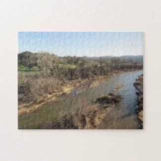
I just made a puzzle of this shot at Zazzle. Here it is. I edited the sunspots out of the puzzle. It is not watermarked, either. 


Salinas River from Vineyard Bridge, Templeton, CA Jigsaw Puzzle


This next photo is a closer look at the part of the scene just beyond the sandbar. 


Salinas River Photos from Vineyard Bridge in Templeton
A Closer Look at the River Beyond the Sandbar Looking South


Next is a closer look at the west bank. You can see the patterns formed in the sand by the flowing river. You can also see how much more of the river was recently covering this.


Salinas River Photos from Vineyard Bridge in Templeton
Patterns Salinas River Made in Sand Near Riverbank


The Salinas River in Templeton Looking North


I also took photos from the north side of the bridge. The Salinas River flows north, not south like most other rivers. It finally empties into the Monterey Bay. This photo focuses on what I see immediately in front of me as I aimed the lens north. You can see the shadow of the bridge falling across the river. 

Salinas River Photos from Vineyard Bridge in Templeton
Salinas River Looking North from Vineyard Drive Bridge in Templeton, 1-28-17

Here is a more detailed view of the west bank. There is still a bit of shadow from the bridge. Notice that some of the water is caught right next to the bank. Here, too, you can see how the grasses in the river are leaning north where the river flowed over them. 

Salinas River Photos from Vineyard Bridge in Templeton
Close-up of West Side of River Near Riverbank


I'm wondering how long this river will remain visible if we don't get more rain soon. 


Salinas River Photos from Vineyard Bridge in Templeton


***

Sunday, July 31, 2016

Skylines: Templeton and Paso Robles

A City Skyline in a Country Town


My town of Templeton is not known for its skyline, but the August theme for  The City Daily Photo Bloggers is "Your City's Skyline." Sorry, friends, but this is about all the skyline Templeton has. The feed and grain store is the tallest building in town and dominates what skyline here is.

A Skyline for Templeton

Like many small towns in America, our commercial areas are spread out, not concentrated in one place. Instead of one big city we have several shopping centers that are closer to residential areas. In the Templeton photo above, you are seeing the few blocks of  commercial concentration on Main Street. This is the historic old town. At either end of this area will find occupied homes, and many of the commercial buildings used to be homes.

If Templeton has a skyline, you see it below. This was taken looking at the back view of Main Street, from across the river. From a distance, most buildings are swallowed by the trees and the Feed and Grain Store building.


The Paso Robles Skyline

Even in my other town, Paso Robles, just a few miles north of Templeton, the skyline is most likely to feature the tops of oak trees. The tallest buildings are about three stories high. What we consider downtown is concentrated around City Park. The public buildings are only a couple of blocks from the park. Spring Street is our main street that crosses town and is one of the streets that borders the park. Twelfth Street is another. You see the skyline looking out toward Twelfth Street  below.


Below you are looking toward the corner of 11th Street and Park Street.


Below is the skyline looking toward Spring Street from the Park.


As you can see, the oaks are taller than most buildings. The only way to get a true skyline photo is to get above the city, but the roads to the surrounding hills have no place to park anywhere near a clear view down.

Paso Robles has several different skylines, but most are in residential areas or smaller commercial areas. This is a medical complex at the east end of Spring Street. You can see the houses on the hill above -- and the trees.


The skyline below was taken from a frontage road  over the freeway that looks down at the newer part of town east of the Salinas River and the 101 Freeway. The Walmart Center is on the left. Between Walmart and the hill in the background sits the Kennedy Fitness Club. On the right is the tract where I live when I'm not in Templeton.


I like living in an area where you can hardly see the buildings for the trees, where surrounding hills and trees make it hard to photograph the skyline.

See real skyline photos from other City Daily Photo bloggers.

Does the city or town that you call home have a well defined skyline?
Related Posts Plugin for WordPress, Blogger...